
The Burren & Cliffs of Moher Geopark have developed a series of Heritage Trails. Available in Tourist information offices, select accommodations and visitor attractions.
Click on the arrows below to see an overview of each trail.
Loop Overview
DISTANCE: 2.3km
DIFFICULTY: Easy
DURATION: 1 hr
TERRAIN: Urban pathways and minor roads
MINIMUM GEAR: Walking shoes, raingear, fluid, mobile phone
1. Ballyvaughan Pier
Locally called the ‘Old Pier’, this structure was built between 1837 and 1877 to facilitate a growing herring fishing industry. It replaced an earlier stone landing pier, the remains of which can be seen in front of ‘The Tea Rooms’ at low tide. The building that houses ‘the Tea Rooms’ was formerly a Coastguard Station.
2. Cuillighageeha
This small area of land between the sea and the road has been enhanced by the local community through the installation of a bird hide, interpretative board and picnic benches. Out to sea are the mud flats of the Rine and clusters of rocks known as Black Island and Farthing Rocks. Watch out for seals sunning themselves on the rocks, a huge variety of birds and the Martello Tower at Finavarra Point on the far horizon. You can learn more about this tower on the Flaggy Shore Geopark Heritage Trail.
3. A Medieval Settlement
A stone castle, which belonged to the O’Loghlen family, chieftains of the Burren, once stood on the small promontory opposite the entrance to the ‘Rent-an Irish cottages’ complex. The remains of a stone quay, adjacent to the promontory, may be medieval in origin and related to the castle. In 1569, Sir Henry Sydney’s forces attacked the O’Loghlens and the castle was destroyed.
4. The Cottages
Ballyvaughan was a pilot area for the ‘Rent an Irish Cottage Scheme’ which started in the late 1960’s. Proposed by Shannon Development and supported by Clare County Council the cottages were developed under the Village Renewal scheme.
5. New Pier
Built between 1874 and 1881, Bournapeaka pier, facilitated the growing herring fishery and oyster production industries of the region. Grain, bacon and vegetables were exported and turf imported from Connemara. Still referred to today as the “New Pier”, it was extended in 2005.
6. The Earliest Piers
Beyond the ‘New Pier’ are a series of rubble stone landing places possibly dating to the 18th century or earlier. These were likely to have been used for seaweed harvesting and fish landings. One is known locally as The ‘Girls Quay’ and its proximity to the 19th century Clareville House, suggests that it may have served as a bathing place for the ladies of the house.
7. McNamara’s Hotel
(now O’Loghlens Bar) featured in many nineteenth century guide books. ‘The principal hotel is on the shore, and in our experience it is well conducted, and one can be made comfortable in it, as we ourselves experienced when staying under its roof. A steamer plys between Galway and Ballyvaughan, taking passengers to and from Lisdoonvarna, and excursions are made also to the Arran Islands from it and from Galway’. Holiday Haunts on the West Coast of Clare (1891). The former weigh bridge, which was used to weigh goods for sale is located adjacent to O’Loghlens Bar.
8. An early public water supply
In 1872, Lord Annaly built a water reservoir outside Ballyvaughan to serve the farming community. The scheme was extended to Ballyvaughan village under the Public Health Act of 1874. This fountain was erected in 1875 by two Connemara stonemasons, the Coyne brothers, who were marooned in Ballyvaughan when their craft sank at Gleninagh pier. A number of plaques on the fountain record the names of those involved in providing Ballyvaughan with one of the earliest reliable public water supplies in the country.
9. A bustling village in the 1840s
In 1841, Ballyvaughan had 235 inhabitants, living in 35 houses. Most supplies came from Galway and the inhabitants exported their grain, bacon and vegetables from the quay. The village had its own courthouse, workhouse, coastguard station and a large police barracks at this time. As you turn onto the main street in Ballyvaughan, the building that today houses Quinn’s shop was a former constabulary barracks in the 1840s. The courthhouse was located in the building opposite Logues Lounge.
10. The Community Hall
The original village national school, built in 1854, was restored and officially opened as a community hall by President Mary Robinson in 1992. A weekly farmers market and craft fair are held here throughout the summer months and during the Christmas season.
11. Workhouses
To provide relief for the poor during the Famine of the 1840s, an auxiliary workhouse operated in the low cut-stone buildings located at the end of this short lane. In 1847, Ballyvaughan Poor Law Union was established and in 1852 a larger workhouse, designed to accommodate 500 inmates, was built. The site of this workhouse is located to the rear of the present day National School along the Ballyvaughan Wood Loop Walk (trailhead at quay).
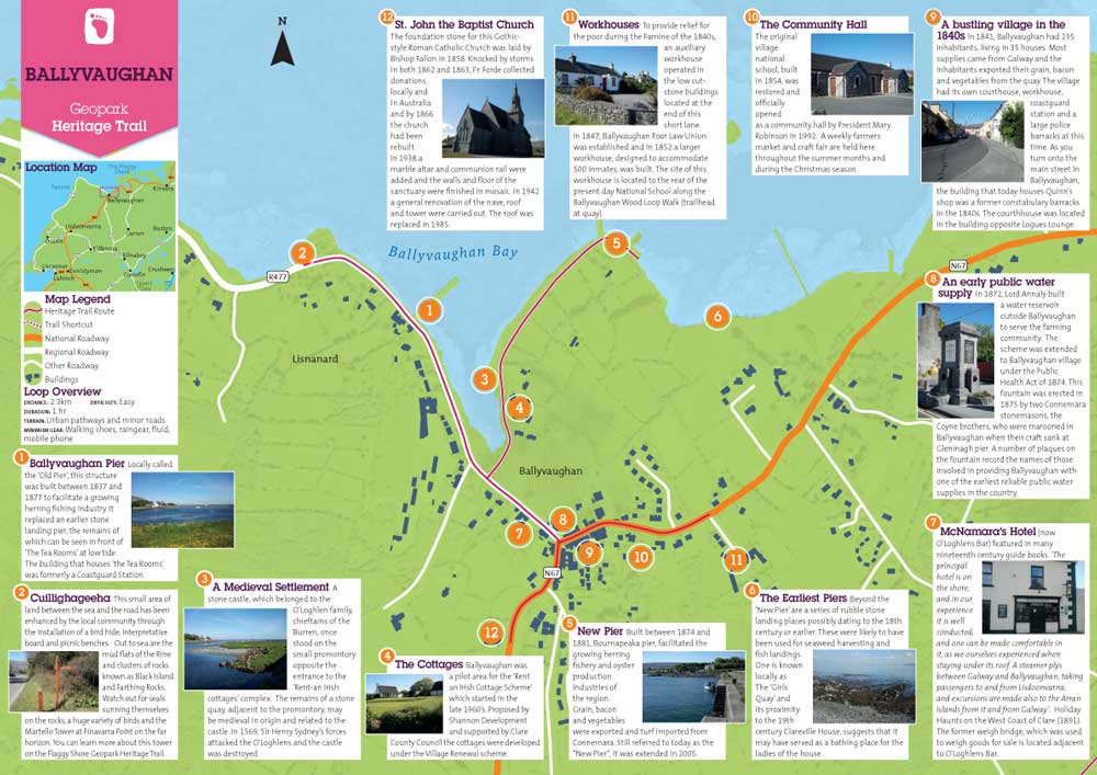
12. St. John the Baptist Church
The foundation stone for this Gothic-style Roman Catholic Church was laid by Bishop Fallon in 1858. Knocked by storms in both 1862 and 1863, Fr. Forde collected donations locally and in Australia and by 1866 the church had been rebuilt. In 1938 a marble altar and communion rail were added and the walls and floor of the sanctuary were finished in mosaic. In 1942 a general renovation of the nave, roof and tower were carried out. The roof was replaced in 1985.
DISTANCE: 2.25km
DIFFICULTY: Easy
DURATION: 1.5 hrs
TERRAIN: Minor roads, urban pathways and farm track
MINIMUM GEAR: Walking shoes, raingear, fluid, mobile phone
1.Heritage, Genealogy and Interpretation
The Clare Genealogical Research Centre, founded in 1982 by the late Dr. Ignatius (Naoise) Cleary and the Burren National Park Information Centre are both located in this building. The Research Centre provides a genealogy service while the information point provides interpretation on the formation, management and flora and fauna of the Burren in an interactive and educational manner. Free guided walks, talks and activities are organised on a regular basis.
2. St Brigid’s Church
was commenced as a relief scheme by Fr John Murphy, during the famine of 1822 on a site donated by Sir Edward O’Brien, M.P., Dromoland. Plans were prepared free of charge by the noted architects, the Pain Brothers, who were then redesigning Dromoland Castle. Completed around 1825, St. Brigid’s was one of the first churches in the county to be built to an architect’s plan. The front doorway was taken from a late medieval church in nearby Kilvoydan (no. 9 on this trail). The mitred head at the front was taken from the old monastic church at Rath (No. 11 on the Dysert O’Dea Heritage Trail).
3. Market House
Built by the O’Briens in the 17th century, the market-house has been the location for many enterprises. In 1788 woollen goods were spun and weaved on the upper floor. In 1812 Rev. Frederick Blood, the local rector, received a donation of fifty pounds from Sir Edward O’Brien to establish a school for the poor in the upper room, based on the model developed by the English educationalist, Joseph Lancaster. Other uses included corn and woollen markets, a Mass house, a military and police barracks, a cinema and most recently a residential development.
4. The Bridge
This three-arched cut stone bridge spanning the River Fergus, built circa1790, is a protected structure. The River Fergus flows under the bridge, linking Lough Inchiquin with Lough Atedaun. This waterway is a designated Special Protection Area due to the great variety of resident and migratory wildfowl it supports and a Special Area of Conservation as it contains several important habitats.
5. Richmond House
was built by Richard Brew of Prospect House, Tullycrine, probably around the time of his marriage in 1786 to Alice Adams of Applevale, Corrofin. Leased by Fr John Murphy in the mid-1820s, the house served as a presbytery for the RC clergy until a new presbytery was built at Laghtagoona in 1886. An outbuilding adapted for use as a school in 1825 served as the first national school in the parish until the 1880s. Among the teachers were Michael Cusack, co-founder of the Gaelic Athletic Association and Seamus Mac Curtain, the self-styled ‘last bard of Thomond’.
6. Micheál’s Lane
This cobbled lane once led down to ‘Corrofin House’ on the bank of the River Fergus. Home of Máire Rua O’Brien after her eviction from Leamaneh Castle, it later passed to her grandson, Lucius, and his wife, Catherine Keightley who lived there between 1706 and 1717. Catherine was a cousin through marriage of Queen Mary and Queen Anne of England. By 1840 the house was in ruins and a distillery had been built close by.
7. Music and Dance
The building which today houses a supermarket was a dance hall in the 1950’s. Over the door is a small plaque with the Irish words “Neart ó Neamh” (Strength from Heaven) and the date 1911.
The Corrofin Teach Ceoil, housed in an original 19th century cottage on Market Street, has been operated by the local Branch of Comhaltas Ceoltoiri Eireann since 1972. A summer “Seisiún” with traditional music, song and dance takes place every Thursday evening in July and August and a traditional music festival takes place each February.
8. Fair Lane
This lane was the original route from Main Street to the Fairgreen, where fair days were held until the 1950’s. There were two annual fairs, one on the day before Ascension-day, and one on November 22nd. The last livestock fair was held in the streets of Corrofin in the late 1960’s.
9. Kilvoydan Graveyard
Associated with ‘Cill Bhaodáin’ a medieval church may once have stood here on the shore of Lough Atedaun. Traces of a circular enclosure, possibly dating to the early medieval period, were still visible in the fields when the first Ordnance Survey map was compiled in the early 1840s. Today a ‘holy well’ and the socketted base of a cross survive to the south-east of the walled graveyard. When a pattern of prayers is undertaken over three days, the well water is said to cure warts.
10. Lough Atedaun
(the lake of the breezes) stretches out below Kilvoydan graveyard. It is a very important waterway for wildfowl and pike fishing. Seasonal changes in the lakes water level due to drainage through the karstic limestone of the region, mean that Lough Atedaun displays turlough characteristics. High surface water levels are indicated by the black moss or turlough moss that grows on the surrounding rocks.
11. The Workhouse
In 1847 as the Great Famine persisted, major changes took place in the operation of the Irish welfare service provided under the 1838 Poor Law Act. Four additional Poor Law Unions were created in Co. Clare at Ballyvaughan, Corrofin, Tulla and Kildysert. Corrofin Union, comprising 1,589 inhabited houses and a population of 9,352 persons, was declared in February 1850. A workhouse to cater for 600 of the destitute poor was completed here in Corrofin village in August 1852. Only the admission block remains today.
12. St Patrick’s Hall
is a community hall built in 1945. The national school was housed temporarily here in the early 1950s. The present National School ‘Scoil Mhuire’, located behind the community hall, was built in 1959. The fields beside the hall are the location for the annual Corrofin Agricultural Show.
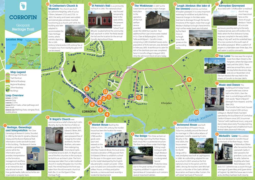
13. St Catherine’s Church & Museum
This church was built by Catherine Keightley, wife of Lucius O’Brien, between 1715 and 1720. In 1820, the vestry and tower were added and stained glass windows inserted. Functioning as a church until 1974, the building was later adapted to accommodate the Clare Heritage Centre, where exhibits depicting life in 19th Century Ireland and a 12th century Tau or T-shaped cross from nearby Roughan Hill can be viewed.
DYSERT O’DEA
Loop Overview
DISTANCE: 5km (9km with spur to Rath Church)
DIFFICULTY: Easy
DURATION: 1.5–2hr (2.5hrs with spur)
TERRAIN: Minor roads and old roadways
MINIMUM GEAR: Walking boots, raingear, fluid, mobile phone
1. Dysert O’Dea Castle
Built between 1470 and 1490 by Diarmuid O’Dea, this castle was partially destroyed in 1691 during the Cromwellian wars. Restored in the 1980s by the Dysert O’Dea Development Association, it retains many original features. Now the home of the Clare Archaeology Centre, the castle is open to visitors between May and September and at other times by appointment. An extensive collection of local historic artefacts, an audio-visual presentation and well-informed tour guides enhance the visitor experience.
2. A Medieval settlement
Adjoining the north exterior wall of Dysert O’Dea Castle are the remains of a medieval house. Located in the wet grassland below the castle and house are a well and two fulachta fia or cooking sites which may have been in use from the Bronze Age up to early medieval times. To the south-east of the castle, at the edge of the car park, are the remains of a second medieval house.
3. St Tola’s High Cross
The placename ‘Dysert’, derives from ‘Dísert – Tóla’, meaning the quiet place or hermitage of St. Tóla, who established a monastery here in the 8th century. This 12th century high cross possibly marked the boundary of the monastery. On its east side is a representation of Christ with arms outstretched, below which is the figure of a bishop, believed to be St Tóla. The detachable (now missing) right arm of the bishop may have been used for bestowing blessing or curing an illness, for carrying in procession or as a talisman in battle.
4. Holy Well
St Tóla’s Well which may have been the water source for the ancient monastery, is located to the south of the High Cross, approximately 100 metres downhill. It was frequented by local people on ‘patron’ day, March 30th, when prayers were recited and intentions sought. This tradition continued until the mid 1800s when the well was blocked up by the landlord, Edward Synge, a noted evangelist. It was re-opened in 1986 and is now surrounded by a wooden fence.
5. Medieval Church
This stone church, much of which dates to the 15th and 16th centuries, is believed to stand on the site of St Tóla’s 8th century monastery. The ruins show evidence of successive periods of re-building and repair. Several of the O’Dea clan are buried within its interior. The magnificent 12th century Romanesque doorway with its highly decorated arch is one of the finest examples of its type in Ireland. The outer order is decorated with twelve human and seven animal head carvings.
6. Round Tower
To the north of the church is the ruin of an 11th century round tower. It is said to have been knocked by Cromwell’s forces during the church repressions of the 1640s.
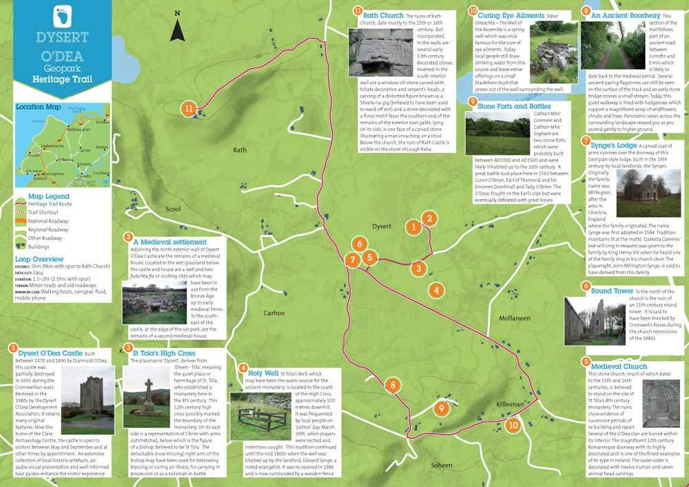
7. Synge’s Lodge
A carved coat of arms survives over the doorway of this Georgian style lodge, built in the 19th century by local landlords, the Synges. Originally the family name was Millington, after the area in Cheshire, England where the family originated. The name Synge was first adopted in 1584. Tradition maintains that the motto ‘Caelesta Canimes’ (we will sing in Heaven) was given to the family by King Henry VIII when he heard one of the family sing in his church choir. The playwright, John Millington Synge, is said to have derived from this family.
8. An Ancient Roadway
This section of the trail follows part of an ancient road between Corrofin and Ennis which is likely to date back to the medieval period. Several ancient paving flagstones can still be seen on the surface of the track and an early stone bridge crosses a small stream. Today, this quiet walkway is lined with hedgerows which support a magnificent array of wildflowers, shrubs and trees. Panoramic views across the surrounding landscape reward you as you ascend gently to higher ground.
9. Stone Forts and Battles
Cathair Mhic Gormáin and Cathair Mhic Eoghain are two stone forts which were probably built between AD1000 and AD1500 and were likely inhabited up to the 16th century. A great battle took place here in 1563 between Conor O’Brien, Earl of Thomond and his kinsmen Domhnall and Tadg O’Brien. The O’Deas fought on the Earl’s side but were eventually defeated with great losses.
10. Curing Eye Ailments
Tobar Oireachta – The Well of the Assembly is a spring well which was once famous for the cure of eye ailments. Today local people still draw drinking water from this source and leave votive offerings on a small blackthorn bush that grows out of the wall surrounding the well.
11. Rath Church
The ruins of Rath Church, date mostly to the 15th or 16th century. But incorporated in the walls are several early 13th century decorated stones. Inserted in the south interior wall are a window sill-stone carved with foliate decoration and serpent’s heads, a carving of a distorted figure known as a Sheela-na-gig (believed to have been used to ward off evil) and a stone decorated with a floral motif. Near the southern end of the remains of the exterior east gable, lying on its side, is one face of a carved stone illustrating a man crouching on a stool. Below the church, the ruin of Rath Castle is visible on the shore of Lough Raha.
Loop Overview
DISTANCE: 1km
DIFFICULTY: Easy
DURATION: 0.5 hrs
TERRAIN: Gravel path, roadside path
MINIMUM GEAR: Walking shoes, raingear, fluid, mobile phone
Lisdoonvarna and its Spa Waters Three small rivers flow through Lisdoonvarna, the Aille, Gowlaun and Kilmoon, all in deep ravines. Each has broken through the upper layer of shale and now flows on top of the underlying limestone. The shales are rich in phosphate, iron sulphide, calcium carbonate and organic matter. Where the shale meets the limestone, there is a layer particularly rich in phosphate and a number of mineral springs discharge from the shale at this point. The town of Lisdoonvarna developed around these natural spring wells, famous for their health-giving sulphur water and they became a major spa tourist attraction in the 19th century.
1. Rivers and Ravines
Lisdoonvarna is nestled within a landscape of rounded hills of shale rock. This shale was formed approximately 300 million years ago when clay sediments settled on the bed of a deep dark sea. Underneath this shale rock is the limestone, that is visible on the surface further north in the Burren. Unlike limestone, shale is not dissolved by water and the rivers flow on the surface. However, because the shale is made from clay particles it breaks and chips easily. Flowing to the left of the trail is the River Aille. The river has dug into the shale over the centuries and created a deep ravine.
2. Wetland Vegetation
Walking along the trail, you are surrounded by vegetation which prefers wet conditions. This reflects the impervious nature of the underlying shale which often causes water logging on the surface when drainage is impeded. Rushes, horsetails, willow herb, ragged robin and sedges grow among the grass of the parkland. The trees that line the ravine of the Aille River include birch, alder, willow, sycamore, scots pine and oak. On the opposite side of the ravine the rounded hills are covered by bog vegetation, including sphagnum mosses, black bog rush, sedges and furze.
3. The Twin Wells
Descending the steps, you are passing through the shale layer to where the Aille River has reached the underlying limestone. In a short space of time, you have climbed down through approximately 20 million years of geological history. At the bottom of the steps are the ‘Twin Wells’. Discovered in the mid-1700s, these wells are a source of chalybeate and magnesia and unusually the two separate wells spring from the same rock. Due to the popularity of the wells in the 1800s, steps were made down from the road above in 1870. An attendant working at the Twin Wells in 1908 earned 10 shillings (60 cent) a week.
4. Riparian woodland
Ascending the steps to rejoin the trail, a second river flows in the ravine to your left. This is the Kilmoon stream which is flowing to meet the Aille River near the Twin wells. All along the banks of the Kilmoon Steam, large trees line the banks. Beech, horse chestnut, sycamore, ash, alder and willow adorned with mosses and lichens are underlain with a shrub layer of holly, hazel, hawthorn, elder, blackthorn and ivy and a colourful ground layer of speedwell, herb robert, cross stitch, celandines and ferns.
5. Pump House
Continuing straight along the trail, passing to the rear of the Burren Salmon Smokehouse, you reach a pedestrian entrance gate to the park. On the opposite side of the road is the Town Library, housed in the former Pump Room of the ‘iron and magnesia wells’ of the Kilmoon stream. It was recommended that people first took a course of magnesia before taking the iron water. The magnesia water was said to be beneficial for those with ‘weak stomachs’, while the iron water was used as a blood tonic and particularly recommended to ‘young and weak females’.
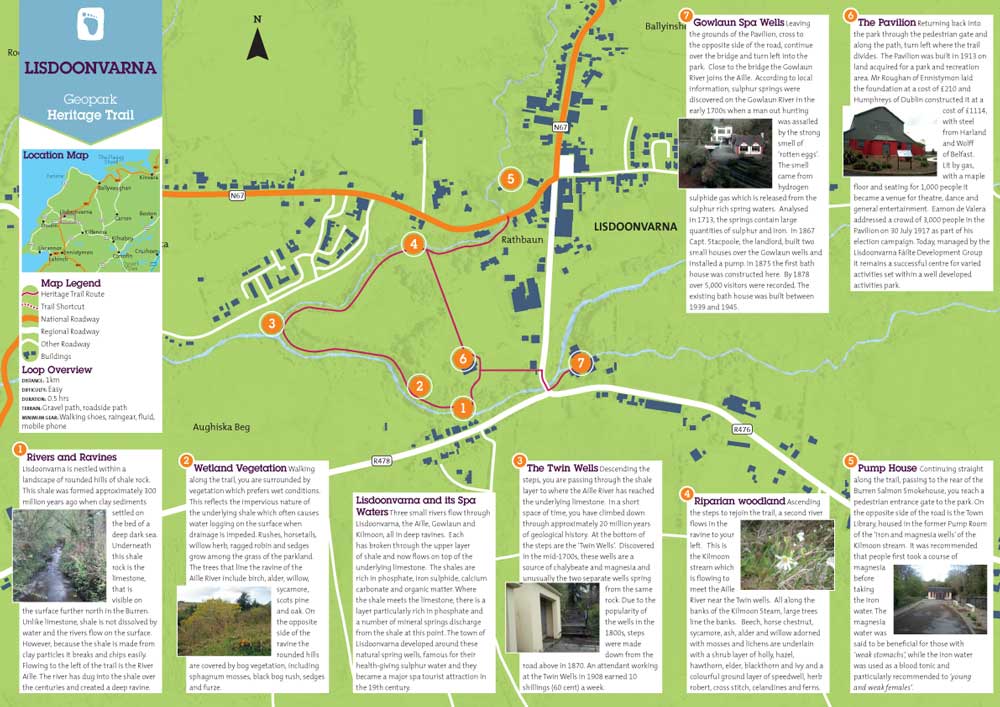
6. The Pavilion
Returning back into the park through the pedestrian gate and along the path, turn left where the trail divides. The Pavilion was built in 1913 on land acquired for a park and recreation area. Mr Roughan of Ennistymon laid the foundation at a cost of £210 and Humphreys of Dublin constructed it at a cost of £1114, with steel from Harland and Wolff of Belfast. Lit by gas, with a maple floor and seating for 1,000 people it became a venue for theatre, dance and general entertainment. Eamon de Valera addressed a crowd of 3,000 people in the Pavilion on 30 July 1917 as part of his election campaign. Today, managed by the Lisdoonvarna Fáilte Development Group it remains a successful centre for varied activities set within a well developed activities park.
7. Gowlaun Spa Wells
Leaving the grounds of the Pavilion, cross to the opposite side of the road, continue over the bridge and turn left into the park. Close to the bridge the Gowlaun River joins the Aille. According to local information, sulphur springs were discovered on the Gowlaun River in the early 1700s when a man out hunting was assailed by the strong smell of ‘rotten eggs’. The smell came from hydrogen sulphide gas which is released from the sulphur rich spring waters. Analysed in 1713, the springs contain large quantities of sulphur and iron. In 1867 Capt. Stacpoole, the landlord, built two small houses over the Gowlaun wells and installed a pump. In 1875 the first bath house was constructed here. By 1878 over 5,000 visitors were recorded. The existing bath house was built between 1939 and 1945.
The Flaggy Shore
Loop Overview
DISTANCE: 8km
DIFFICULTY: Easy
DURATION: 2.5– 3 hrs
TERRAIN: Minor roads
MINIMUM GEAR: Walking boots, raingear, fluid, mobile phone.
1. A tsunami hits!
As you stand at the Flaggy Shore beach the low lying cliffs of Aughinish Island are visible across the water. It is believed that a stretch of land originally connected Aughinish Island to New Quay. When a tsunami wave travelled up the west coast of Ireland after the Lisbon earthquake of 1755, the connection was washed away.
2. Art and Literature
Built by local landlords, the Skeretts, around 1790, Mount Vernon became the summer home of the Lane family in the mid 1800s. Hugh Lane founded Dublin’s Municipal Gallery of Modern Art. In 1880, the house was presented to Lady Gregory of Coole Park (Hugh’s aunt) as a wedding present from her husband. WB Yeats, George Bernard Shaw, Edward Martyn, Oliver St. John Gogarty and J.M. Synge were regular visitors. In 1907, Lady Gregory presented the house to her son, Robert, on his marriage. Roberts’s daughter Anne recounts her memories of summers at Mount Vernon in her book ‘Me and Nu’.
3. Tropical seas, glaciers and rock boring shellfish
Flat slabs of limestone reach out into the sea along the Flaggy Shore. Embedded in these rocks are the fossilised remains of plants and animals that lived here in a tropical sea over 330 million years ago. The abrasive action of a glacier passing over this shore approximately 12,000 years ago created visible surface scratches on the rocks. Scattered among the shingle, small rocks pitted with holes, indicate the presence of a small shellfish (a piddock), using the serrated edge of its shell to create shelter burrows.
4. Underwater exploration
This karstic limestone coastline is famous for its clarity and biodiversity. It is part of the Special Area of Conservation of Galway Bay. Coralline algae reefs, seagrass beds and rare red and brown algae live offshore. Piddocks, sponges, sea urchins, oysters and numerous other marine creatures feed among these plants. A colony of common seals, a population of breeding otters and a huge variety of birds are all part of this web of marine life. The National University of Ireland, Galway’s marine research station, located here, provides facilities for scientists undertaking research on this unique environment.
5. A Special Lagoon
Lough Murree or Muirí, is the best example of a karstic lagoon in Ireland. Stretching over 14 hectares, it supports diverse, specialised and in some cases rare, animals and plants. Along this coastline, waterfowl, shorebirds and gulls are frequently sighted. Several of the bird populations occur in numbers that are of national importance. The Brent Geese that fly in from Arctic Canada and Greenland, to feed and roost in winter, are of international importance.
6. Attack Finavarra
Martello Tower was built around 1810 as part of a series of shore defences. With three rooftop guns and 39 men, it was prepared for a Napoleonic attack that never happened. The building in front of the tower was the guard-house. A line of upright stones, engraved with WD, an arrow and a number, indicate the boundary of the land which was in use by the British War Department. Stone number 15 is located close to the entrance gate.
7. Shellfish Production
Pond House, located along the shore, was built by the Skerett family as a boat house. Breakwaters and sluice gates, constructed in the late 1800s created a lobster pond to the front of the house. Up to the late 1950s a highly successful lobster exporting business to London and continental Europe operated here. Beyond Scanlan’s Island, Pouldoody Bay was famous for its oysters in the nineteenth century. The agricultural surveyor Hely Dutton claimed in 1824 that ‘all oysters are greatly inferior to Pouldoddy’.
8. Finavarra and The Skeretts
As you pass through Finavarra village you will notice high stone walls begin to dominate as the remains of an 18th century demesne come into view. The Skeretts were one of the famous fourteen medieval merchant tribes of Galway City. The ruins of their great house, demesne walls, two gate lodges and walled garden still dominate the clustered village settlement at Finavarra.
9. A Bardic School
The O’Dálaigh Monument is located opposite the site of a Bardic School conducted by the O’Dálaigh family during medieval times. History, law, language, genealogy and literature were taught. Donnchadh Mór O’Dálaigh became a very famous poet and was known as ‘the Irish Ovid’. He died in Finvarra in 1244 and the monument is dedicated to his memory.
10. New Quay House
was built in the 1800s by the Skerret family. It fell into ruin for several years before being purchased from the Church of Ireland rector, Canon Elliot by the Purcell family in 1917. Mr Purcell had just returned from Bulawayo. He renovated the house and renamed it as Rhodesia Lodge.
11. New Quay
‘that once fashionable and quiet bathing place’ as described by T.L. Cooke in 1851 in his ‘Autumnal Ramblings around Newquay’ is today a very popular seafood retail and dining destination. The pier was built by the Fisheries Board in 1837 to replace the ‘Old Quay’ which stood slightly to the west. George Bernard Shaw placed the scene ‘The tragedy of two elderly gentlemen’, part IV, act 1 of Back to Methuselah on this pier.
Guided Walk
Guided Foraging/Wild Walk